Need some mountain time? Try these easy North Carolina hikes

Summer is about the time we start thinking about escaping to the mountains and enjoying the splendor of our Southern Appalachian mountains.
Despite the popularity of hiking in the Southern Appalachians, especially come summer, there are plenty of trails where you can find solitude and not push yourself to the limit. A lot of these trails can be found, conveniently, along the Blue Ridge Parkway.
There’s a second advantage to hiking along the Parkway: because the Mountains-to-Sea Trail, our statewide hiking trail, parallels the Parkway for much of its mountain run, there are perhaps 100 access points (maybe more), where you can pick up the trail. This means that if you come to a roadside trailhead full of cars, continue down the Parkway – you’re likely to find an empty trailhead within a few miles.
Here are five the best hikes in western North Carolina, offering miles of trails throughout the Blue Ridge Mountains and some of the highest peaks and best views the Tar Heel State has to offer.
1. Mount Mitchell State Park
NC 128 off the Blue Ridge Parkway (2388 N.C. 128, Burnsville)
Various trail options up to 2 miles
This venue takes into account your need to escape the summer heat. Here atop the eastern seaboard – at 6,684 feet, Mount Mitchell is the highest point east of South Dakota’s Black Hills – the temperature can be considerably cooler than down in the Piedmont. (Generally, the temperature drops 3.5 F for every 1,000 feet of elevation gained).
Expect crowds on the short trail from the main lot to the summit; expect fewer people on the mile loop Balsam Nature trail and fewer still hiking the 0.8 miles on the Black Mountain Crest Trail to Mount Craig. You may find even fewer hikers on the 2-mile Old Mitchell Trail (part of the MST). Bring fleece (no kidding)!
2. Mountains-to-Sea Trail below Graveyard Fields/Yellowstone Prong
Blue Ridge Parkway Milepost 418.8 (Graveyard Fields parking lot)
A half mile or more
Don’t be alarmed if the lot has cars. The majority of hikers here are taking the spur down to the MST and heading west (left) toward the heart of Graveyard Fields. Go right, heading east, and drop through a series of small waterfalls along Yellowstone Prong.
You won’t find the open views you would heading west, but you will find solitude and beauty along this mountain creek as it drops through a Southern Appalachian forest. It’s the MST, so it’s well-marked with the trail’s signature white circle blaze; no worries about getting off track.
Do, though, keep track of your time hiking down the trail: your return is uphill and will take considerably longer. This is an out-and-back trail.
3. Pink Beds
US 276, about 4 miles south of the Blue Ridge Parkway (GPS: 35.3533203, -82.7808854)
5.1 miles
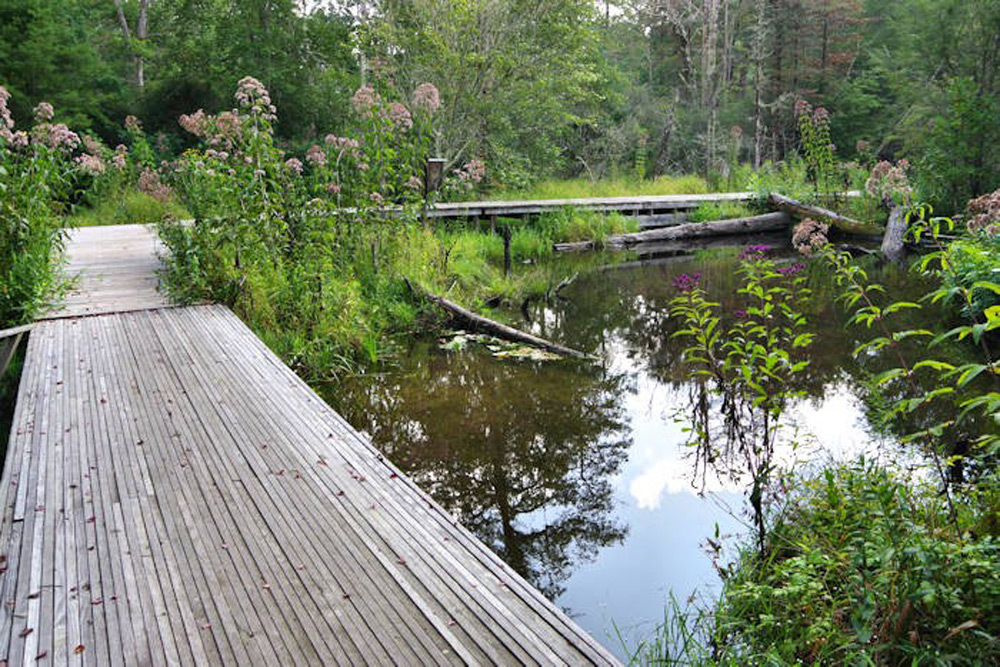
We don’t know of too many mountain loop trails with a negligible change in elevation, yet that’s the case here at Pink Beds, a rare Appalachian mountain bog around which the trail travels.
As you might suspect with a bog, some parts are marshy: those parts are navigated via well-placed boardwalk and bridges. Starting from the parking lot and hiking counterclockwise, you’ll pass through a grassy meadow and cross several boardwalks as you navigate a forest carpeted in ferns, covered above by hardwoods and the occasional hemlock. About midway through, you enter a more mature forest and encounter a mountain pond.
Again, if the lot has cars, they’re likely picnicking at the nearby picnic area. You may see hikers on the trail, but not many.
4. MST: Boone Fork to Holloway Mountain Road
Blue Ridge Parkway, Milepost 299.9 (Boone Fork Parking Area)
3.8 miles
The 88-mile stretch of the MST from Beacon Heights to the Devils Garden Overlook contains some of the most under-appreciated gems of mountain hiking in the state.
One such gem is this 3.8-mile stretch, which includes passage through a quiet, almost magical forest of old growth hardwoods and rhododendrons. The path then goes through a personality change to meander over gentle hills and pass through mountain meadows.
The trail is foot-friendly, the terrain a mix of flat, and gentle rollers. It is, perhaps, the easiest stretch of MST hiking along the Parkway and one accessible to most.
Note: As described, this is a point-to-point hike; you’ll either need to hike back, for a total 7.6-mile hike, or arrange a shuttle.
5. MST through Doughton Park
Blue Ridge Parkway, Milepost 242.3 (Alligator Back Overlook)
1.8 miles (3.6 miles out-and-back)
Open country is hard to come by in the Southern Appalachians, but not at Doughton Park, which runs along the Parkway for about 8 miles.
There are 30 miles of hiking trail in Doughton Park. We recommend this stretch because it takes in a bit of the rugged as well as the vast meadows Doughton is known for. From the Alligator Back Overlook climb a half mile to the summit of Bluff Mountain to experience the rugged, then continue on a long drop through open meadow.
Occasional rock outcrops, a wind-whipped tree here and there, long views, possibly cows, definitely cow paddies. Walk down to the Bluffs Lodge (closed), and detour right on the road a short distance to the Wildcat Rock Overlook, where you can peer into a steep valley and see the Caudill Cabin 800 feet below. Return to the lodge, then continue on to the Bluffs Coffee Shop, which likely is closed. The hike back is more of the same – a good thing.
Browse related articles


Blue Cross and Blue Shield of North Carolina does not discriminate on the basis of race, color, national origin, sex, age or disability in its health programs and activities. Learn more about our non-discrimination policy and no-cost services available to you.
Information in other languages: Español 中文 Tiếng Việt 한국어 Français العَرَبِيَّة Hmoob ру́сский Tagalog ગુજરાતી ភាសាខ្មែរ Deutsch हिन्दी ລາວ 日本語
© 2024 Blue Cross and Blue Shield of North Carolina. ®, SM Marks of the Blue Cross and Blue Shield Association, an association of independent Blue Cross and Blue Shield plans. All other marks and names are property of their respective owners. Blue Cross and Blue Shield of North Carolina is an independent licensee of the Blue Cross and Blue Shield Association.